
February 9-17, 2019

Our Home in Rio Grande Village
Big Bend National Park is BIG! We quickly learned to leave at least an hour to drive to anywhere. We started on the East Side of the park and toured that area plus the central Chisos Mountains section before we switched to a campground on the west side of the park and toured over there. This worked quite well for us and kept us from having any truly evil driving days within the park. Big Bend protects a portion of the Chihuahuan Desert, which we expected to be pretty barren. We were pleasantly surprised to find that it had lots of plants and animals to discover as we explored. However, it has very little shade in some areas and it is dry so you ALWAYS have to have extra water with you and go prepared to protect yourself from the sun.
Rio Grande Village
We were able to reserve a site in the Rio Grande Village NPS Campground for three nights and then were lucky to switch to a beautiful non-reservable site after that (see above photo). We used this as our base of operations for our hikes, ranger programs and general adventures on both the west side of the park and Chisos Basin. We would have LOVED to camp up in Chisos but they strongly recommend that no RV’s over 24 feet attempt to navigate the twisty, turny road. After driving it in the Subaru, we knew we could have done it with the RV but the stars would have had to align perfectly for us to get up there at the same time a site came open that was big enough for us. We figure MAYBE half the sites could handle the rig with the car parked up in the overflow lot but many were definitely tent sites with barely enough room for a standard size car to park. It was about an hour’s drive from Rio Grande Village to Chisos Basin so no biggie. We stayed down along the river. The NPS campground has no hookups and was full by noon every day we were there. You are allowed to camp within the park (any combination of the three campgrounds and backcountry sites) for a total of 14 nights during the December to March busy season. This doesn’t mean two weeks camping, out for a day and back in again. It is two weeks TOTAL. I don’t know how or if they can even track that but we planned our play time so that we stayed within that two week limit.
There are two camping areas on the east side. One is the Rio Grande Village Campground which is run by NPS and has no hookups or showers but does have a dump station and fresh water. A little less than half the campground is a designated “no generator” zone. I wish we had camped in the no genny zone but we just bought a little, untested 100W solar suitcase and weren’t sure we’d get enough power to keep the fridge happy so we chose the evil noise zone. And it is evil noise. There were huge rigs and small rigs that ran their generators from 8am to 8pm. Some had large commercial generators that they dragged out across the camping area to put the noise as far away from their rig as possible… and closer to other people. So inconsiderate! The other camping area is the Rio Grande Resort which is a paved parking lot with full hookups. This is run by the concessionaire that also operates the camp store, laundry and pay showers. THIS is where the rigs that want full power all day belong. I know it is $36/night instead of $14 but if you need power, pay for power and let the rest of us have a break from the noise! I doubt the no generator zone was truly noise free as it is just a separate part of the same loop. There are some nice pull throughs over there with shade though. If we go again, we’ll be as far from the generator area as we can get and our solar suitcase will keep our batteries charged.
Nature Trail
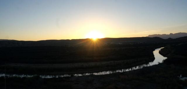
Sunset over the Rio Grande
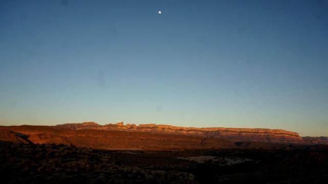
Nearly full moon over sunset-reddened Sierra Del Carmen Mountains
There are several very nice trails within five miles of the campground. The short nature trail in the campground crosses a marsh with raised walkways and benches then climbs a small mountain crest where you can watch beautiful sunsets in one direction and the pink and gold glow of the setting sun on the Sierra Del Carmen Mountains opposite it. The campground and marsh are great areas for watching birds and other critters. It kept drawing us to it so we hiked up the little mountain at least three times in the nine days we spent in that campground. I got to see a pair of Nutria with about five pups swimming in the pond and feeding on marsh grass. I know they are an evil invasive, but they were really cute and fun to watch.
We hiked the Boquillas Canyon Trail during an Archaeology Ranger program and learned about the “mortar holes” where the natives ground pinion nuts, seeds and grain. When the holes got too deep, they started new holes. You can find sets of holes down at river’s edge and on higher ground near the start of the trail. We highly recommend the Ranger programs. We learned so much more than we would have if we had toured the areas on our own. They had one each morning at different locations around the park and evening programs in the campground amphitheaters.
Boquillas Border Crossing
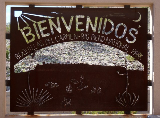
Boquillas Border Crossing welcome sign
We checked out the beautiful ironwork at the Boquillas Border Crossing. The border station is not nearly as impressive or imposing as the one in and near the big cities. Our passports are expired so no riding into the town of Boquillas Del Carmen on burros for lunch – bummer. I checked out the burros through binoculars and they are cute! The Crossing was open Wednesday through Sunday but closes at 5pm so if you do cross over, limit those Margaritas… but just in case you forget and don’t make it back in time, there is a hotel in town. The crossing is located a few miles from Rio Grande Village and is a popular day trip. You go through customs (using a scanner and video screen to get cleared by someone in an office somewhere far away) then walk down to the river where you pay $5.00 American to be ferried across the river in a rowboat. You can then walk up into the town or pay another $5.00 to be transported (round trip) by burro. We’re told the town has several restaurants, a few shops and a hotel. Residents of Boquillas also cross the river and leave handmade souvenirs for people to buy along the trails.

Handmade souvenirs from Boquillas, Mexico
Popular items are walking sticks, bright colored cloths, and plants and animals made out of wire and colored beads. Purchases are made on the honor system as the “stores” consist of a big rock so there’s no checkout line. Note that the park’s paper will tell you it is illegal for the people to cross over and leave the items and it is illegal to purchase the items. We saw a lot of people buying these items without repercussions. This particular enforcement is pretty far down on the priority list. One ranger told us that the proceeds go into a community fund for the town. Another told us that the town had built a community solar set up a few years ago so they have town-wide electricity for the first time. I could be wrong but my brain put the two comments together and wondered if those walking sticks and other items funded that solar array. Another interesting note about the residents of Boquillas is that many of them are members of the “Diablos” and serve as one of the firefighting teams of Big Bend National Park.
Not So Grand Rio Grande
For those that remember the old John Wayne westerns, the Rio Grande (the BIG River) you see today will have you scratching your head in confusion. There are no great flows of rushing water that man, horse and cattle fight to cross (see above photo). There is a shallow river that in some places would be considered a stream. The Rio Grande (called Rio Bravo del Norte in Mexico) begins in Colorado’s San Juan Mountains and flows 1,885 miles to the Gulf of Mexico. Sadly the river isn’t so grand anymore. So much water is siphoned out for human use that it’s reduced to a trickle by the time it reaches El Paso, Texas and a child could easily step over it. If you then follow it to the east, the Rio Conchos River in Mexico flows into it and it becomes a flowing river once again. But it’s still not the Rio Grande you see in the old Western movies.
Hot Springs
We wandered down to Hot Springs but did not get in as it was wicked hot out and sitting in 105 degree water did not appeal. Many people were there enjoying the heat of the spring then cooling themselves in the Rio Grande before repeating the process. There are some fossils and petroglyphs right on the trail as well as the historic ruins of a ranch house and bathhouse from when it was a functioning business. We missed our shot at getting back to the hot springs to play so it is on the list for a future adventure.
Barker House
They had a great Ranger program at the Barker House which is just two-tenths of a mile past the road for the Boquillas Crossing. The park service is trying to find someone to restore the historic house and operate a business out of it. If you know anyone with a couple hundred thousand dollars to spare that wants to restore the building then cater to thousands of tourists, pass on the info. There is a beautiful shaded veranda that overlooks the Rio Grande. One tourist recommended a Margarita Bar. I don’t know if the park would allow that, but it could be a huge hit… at least in the winter tourist season.
Old Ore Road and Ernst Tinaja

Amazing example of nature as art
The Subaru got to earn that “Sport Utility” part of her title by driving the 4.5 miles out Old Ore Road (an “improved” dirt road). We stopped at Ernst Tinaja and hiked the trail up through the wash where we saw the most incredible layers of colored rock rolled and twisted and fractured along the sides of the canyon. The hike was fairly easy and leads you into this beautiful canyon carved through rock walls made of hundreds upon hundreds of thin multi-colored layers, like a fine, flaky pastry. In some places the layers curved gently, giving way to gentle subterranean pressure. Still other layers formed shapes that looked like 3-D contour maps. In other places, the pressures were so immense that the layers snapped and bent at odd angles.

Tinaja nestled in a sculpted landscape
The big tinaja was really cool too. Wait, you don’t know what a tinaja is? It’s basically a hole with water in it. Past water flows or uplifts or whatever create a depression in the land that fills with rain water and holds it. Animals use these holes during dry periods and folklore says that the soldiers chasing Poncho Villa used to swim in this particular tinaja. We didn’t jump in but it was a really beautiful spot. This particular tinaja is about ten feet across and quite deep. It is set down in polished rock in that gorgeous canyon. It’s a great place to sit and look out at the world and enjoy the wonders of nature… until the sun gets high enough to bake you in that canyon. The road is rough but we saw regular sedans making it through so it is doable for most people. Apparently all dirt roads become questionable after a heavy rain so always check before heading out. After doing this hike, we purchased a small guide book about the Big Bend area and discovered we’d missed a stone “chimney” formation farther up the canyon (past the big tinaja) that you can climb up through. We were not going to drive back out that road for a redo but we did make a point of checking the book to read about our future planned hikes and areas BEFORE going after that miss. The book is “The Big Bend Guide” by Allan Kimball. John didn’t like the layout of the information but once we got used to it, we found it to be a handy guide for newbies. It covers the entire Big Bend area, not just the National Park. It has sections like “top 10 hikes”, top itineraries for one day, three days, etc. Some of the itineraries were far more than we would want to do in one day but it still helped with lots of tidbits of information.
Dougout Wells
During the early history of the NPS, anything that smacked of civilization was relocated or destroyed. The goal was to return the park to its “natural state”. More recently, NPS has come to realize that preserving the history and what people built here is also important. Dugout Wells, an oasis, is one such place. What the people who lived here left would once be considered trash but are now historical artifacts. Removing them is illegal. During the ranger program we took a walk and ran across the metal skeleton of an old Ford Model T truck. We also learned that there are such things as ecofacts which are plant-based artifacts. The people who lived at Dugout Wells planted a date palm tree, definitely not native to the area, but it is protected as an ecofact and so it still stands.

Historical Artifact – Skeleton of Model T Truck
Grapevine Trail and Balanced Rock

Balanced Rock on Grapevine Trail
We drove out another “improved” dirt road (again, NOT the word we would use to describe it) to reach the Grapevine Trail which is a fairly easy trail wandering up a wash… until you hit the rocks and it is time to scramble. We lost the trail once and crawled through rocks the wrong way but it all worked out and we were rewarded with a beautiful view out across the dessert from beneath the massive balanced rock.
Critters


Critters: We saw our first ever roadrunner right there in the campground, tons of birds (including the beautiful Vermillion Flycatcher, Great Blue Heron, Egrets, finches and more), a Jackrabbit, Nutria and the tracks of the Javelina, but sadly, no Javelina chose to visit our campsite. That could be good and bad. We really wanted to see them but were also warned that some of them can be quite aggressive. Javelina look like little pigs but are actually Peccaries, which are rodents and, we were told, smell like skunks.
Packrats (we didn’t see any but did learn about them) – It’s amazing what scientists can use to learn about an area. In Big Bend, scientists study packrat middens that can be thousands of years old. A midden is a collection of plant and animal material piled over the entrance of a packrat burrow to preserve the moisture level in the burrow and to keep out predators. A packrat may also urinate on the debris pile which crystallizes and helps stabilize the midden. By studying these middens, scientists can learn how plant and animal communities changed over time which provides evidence of past changes to the climate. Example, when once the midden was built using oak and pine, the newer layers are built using cactus and dessert plants.
J&H
