
April 17-21, 2019
We headed east out of Grand Canyon National Park, skirted the beautiful canyons on the Little Colorado River and swung north and up toward Page. Before the climb up to that plateau we angled west on 89A toward Marble Canyon, Navajo Bridge, Lee’s Ferry and Vermilion Cliffs National Monument. We were looking for a nice campground and heard that Lee’s Ferry just might fit the bill. Friends had been there just a few weeks before us and told us that they were thrilled to be mere feet away from California Condors resting on the bridge and flying overhead. This sounded perfect to us so we decided to camp out at Lee’s Ferry and make frequent visits to the bridge to enjoy the condor. Shortly before we reached Lee’s Ferry, we crossed the Colorado River via Navajo Bridge (in the picture below). This can be a little confusing. You aren’t seeing double. There are two bridges and BOTH bridges are called Navajo Bridge.

Original Navajo Bridge (right) and new auto bridge (left)
Navajo Bridge
The first highway bridge made the ferry obsolete and has itself become obsolete. A new, wider bridge was built next to the smaller one. The original Navajo Bridge has become a pedestrian bridge where you can gaze at the cliffs of Marble Canyon, watch rafters float the Colorado River below, then swing your eyes up to be thrilled by the Condors that fly overhead. This is part of the Glen Canyon National Recreation Area. There is a visitor center with a film, gifts, souvenirs, tourist info and snacks with a parking lot for the bridge on one side and a shelter with Native American craft tables and a smaller parking lot on the other.

View of the Colorado River below Navajo Bridge
Though you appear to be in the middle of nowhere, there is also a hotel/restaurant/general store-gift shop/laundry/post office/gas station/convenience store complex nearby. We had several very good meals at the restaurant and did our laundry at the extremely clean and low priced laundromat. There are several more settlements farther up 89A and each has a hotel of sorts. BE AWARE – most of the food places served only dinner during the week. You are mostly stuck with snack foods from gift shops or gas stations the rest of the time. Weekends offer more hope of food during the day.
Lee’s Ferry – Then and Now
As with much of this area of the west, Lee’s Ferry was established by the Mormon Church. In 1871 John D. Lee established a ferryboat service here to enable Mormon settlers to safely cross the Colorado River so they could colonize Arizona. They would cross their wagons on the ferry, climb a steep rise on the other side (nicknamed Devil’s Backbone), and then continue on to establish settlements farther south. It’s said that Mr. Lee was specifically sent here by the church to hide him because of his alleged involvement in the Mountain Meadows Massacre. He packed up his household, established Lee’s Ferry, built a ranch and raised his family. He was eventually tracked down, tried, and executed in 1877. I guess hiding in a spot where hundreds of travelers pass on a regular basis wasn’t the best plan… not to mention NAMING it after himself. That was not really a good way to “hide” in plain sight, though to be honest it worked for a number of years. Several other families followed in the footsteps of the Lees continuing to run the ferry and raise their families along the river.

Remains of Charles H. Spencer Steamboat near Lee’s Ferry site
This site has several historic buildings that served multiple purposes over the years. You can do a self-guided walking tour around the buildings at the ferry sites, another through Lonely Dell Ranch along Pariah River, and check out a sunken ship visible just below the surface of the Colorado (it was meant to run coal for a gold mining operation but it was built for a lake, NOT the mighty Colorado). The ferry stopped operating when the highway bridge was built just downriver and things got quiet for a while.

Grand Canyon River Trip preparing to launch. The cable over the river is Mile 0
However, this is once again a bustling site but for a very different reason. People no longer need the ferry to CROSS the Colorado. They now use the site to access the water and travel ON the Colorado. All the rafting trips through Grand Canyon launch from HERE. Once you float past this spot on the river, it is 277 river miles before you reach a road where the rafts can be taken out. Lee’s Ferry is also the take-out spot for people that float down the river from below Glen Canyon Dam. Large tour boats floated downriver with dozens of people on them. When they pulled out they hopped on a tour bus to circle back up to Glen Canyon where they started. If you have a kayak, you can schedule and pay a transport fee and those tour boats will take you and your gear back upriver with them after they drop their passenger. You can then enjoy a leisurely two day float back down to Lee’s Ferry where you left your car. The ferry ramp and dock are also used for daytime boating. Quite a few people at the campground brought boats so they could cruise up canyon for sightseeing and fishing (the world famous Horseshoe Bend is 7 or 8 miles upriver). The campground host would check sites by 7 a.m., spend the day on the river in his boat and return to check again in the evening. What a perfect job for a fisherman!

View of Colorado River from our campsite
Lee’s Ferry Campground
This was a really nice campground that is OUT OF THE WAY. We managed to snag a site with a gorgeous view of the Colorado River. We sat in the shade of our awning and typed away on our blog with the sound of the river rushing over the rocks. The views were amazing. To our front was the Colorado River racing past a tall red rock wall. To our back were the Vermilion Cliffs. It was a beautiful, peaceful place to be. The campground is first come first served and we lucked out to get a site at 10:00am on the day we rolled in. There were quite a few open that day but the campground seemed to be pretty much full most days after that. It is probably that whole spring break phenomenon. We wisely rolled in on a Wednesday and beat out the Easter weekend crowd. We kept an eye on the primo “river front” sites at end of the loop and rolled into one on our second day just as someone rolled out. Each site has a permanent shade shelter to keep you cool and nothing between you and the gorgeous views. After we switched sites, we dropped another pay envelope in the box to extend our stay and happily settled in.
Those that follow our blog know that we own a Phoenix Cruiser. This small manufacturer only produces about 3 or 4 units a week so Phoenix Cruiser sightings are few and far between. But lo and behold, one had rolled into the campground in the middle of nowhere just minutes before us… and we knew them!! We had met at the annual Phoenix Cruiser Travel Club reunion in Duluth, MN last fall. It was really neat and we got to hang out with them a bit before they moved on. (Hi P&B!)
The campground has a dump station about a tenth of a mile up the road. Potable water and restrooms with flush toilets are available in the campground itself. There are NO hookups. We hit the dump station to empty our holding tanks and refill our fresh water then scurried back to camp to set out our little solar panel and we were good for the duration. We thankfully never had to run the generator but many neighbors did.
So who operates the campground? I was seriously confused but the Internet helped me out. Lee’s Ferry and Lee’s Ferry Campground are part of Glen Canyon National Recreation Area. HOWEVER, the river and the banks of the river below the Mile 0 cable and Pariah River (including the little swim beach and fishing area that Lee’s Ferry campers use) are part of Grand Canyon National Park. So the rules actually change when you get within forty feet or so of the river. You could probably get a picture here with each of your feet in a different National Park.
Hiking
You can pick up hiking info and guide pamphlets at the visitor center at the bridge.
Lee’s Ferry Hike: There is a short hike from the boat launch area to the original and second sites of Lee’s Ferry. You can still see bits of the road across the river that the settlers used to climb up and over the steep and rocky “Devil’s Backbone” to reach Arizona and push on for westward settlement. This hike is where you see the sunken ship and view of Devil’s Backbone shown in the pictures above.

Trail in Cathedral Wash
Cathedral Wash: A few miles down the road from the campground is a very popular hike through Cathedral Wash. John did this hike with friends and they said it was an excellent hike BUT they did not reach the Colorado River as they had come to a spot that would have required more climbing ability and agility than they had – NOT something they were up for that day. They watched other hikers crawl and slide down a 20 to 30 foot drop off and had to wonder if they had given any thought to how they were going to get back up.
Spencer Trail hike: This is a seriously steep, unmarked, unmaintained hike pretty much straight up and over the cliffs by the ferry. It was an attempt to build a mule train road to transport coal for the mining operations that were taking place in the canyon. We stared up the cliff face and could make out the first short piece of the trail but that was it. We didn’t even attempt it.

Pariah River with trail on the left
Pariah River: (rhymes with Maria) joins the Colorado just below Lee’s Ferry. You can wander up this trail as far as you like then turn around and come back down. Hikers that spent days or weeks in the back-country hiking the Paria Canyon through the Vermilion Cliffs pop back out into “civilization” at Lee’s Ferry. Right near the junction of the two is the Lonely Dell Ranch. You can do a self-guided tour around the ranch buildings and orchard and get a taste of what it might have been like for those early Mormon Pioneers that were sent out to build and man the ferry across the Colorado River. The settlers had a pump to get the water from Pariah River up into their irrigation canals. This was an ongoing project as the heavy silt in the river kept clogging the pump. They could only pump when the stream ran clear. We stared at that water and the dry soil that it runs through and wondered exactly how often it ran clear.
NOTE – You need a BLM permit if you want to go farther up canyon and stay overnight or start at the top and hike down, camping along the way.
Nature
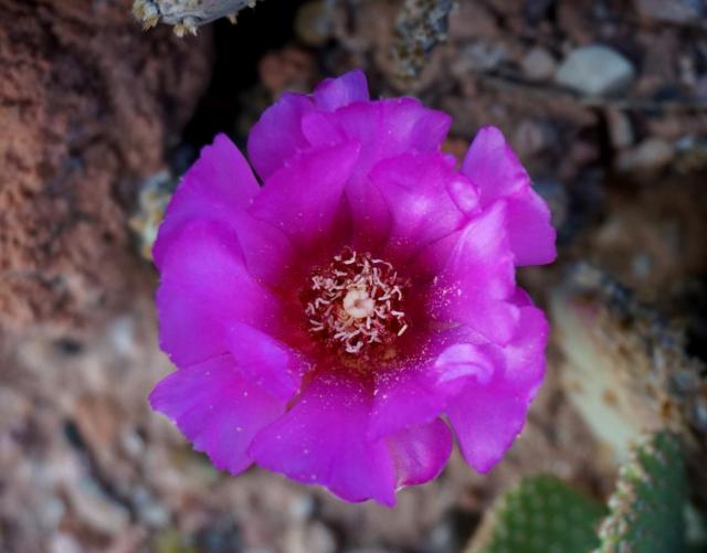

Prickly Pear Cactus in Bloom
Lee’s Ferry wasn’t as green as some other desert areas we’ve been in but since we were in the riparian zone along the Colorado, some of the plants were getting plenty of water. One plant of note is the prickly pear cactus. We saw the buds on the cactus WAY BACK when we camped at Big Bend, but we moved on before they bloomed. We saw buds at Organ Pipe National Monument and kept checking and hoping they would pop… but we moved before they bloomed. We saw buds at Seguaro National Monument… but, again, we moved before they bloomed. So imagine our thrill when we looked down the slope from our campsite at Lee’s Ferry and the prickly pear cacti WERE IN BLOOM!!! We were stunned. We never thought they would put up such big flowers arrayed in little crowns across the top of each pad. FINALLY we got to see prickly pear cactus in bloom and they were gorgeous. Who would have thought those flat little prickly pads could put on such an awesome show?

Great Basin Rattlesnake came a courtin’
Critter Alert – While we LOVE nature and critters of all types, we were not excited when a Great Basin Rattlesnake decided to visit our campsite. We tracked him as he checked out our car, our solar panel and finally our motor home before we successfully encouraged him to move along. He only made it behind the parking bumper of the next campsite where he decided to take a nap. SERIOUSLY? A Ranger came along and tried to catch him with a snake loop but he wasn’t in the mood and we lost track of him in a bush next to that parking bumper. The Ranger explained that she preferred to not relocate snakes because they will expend all their energy trying to get back to their home territory and many die doing so. Apparently Great Basin Rattlers are pretty chill (ours sure was) so you should just let them go on their way. We encouraged ours to move along because we didn’t want him up in our undercarriage or sitting under our step when we put our feet out there in the morning. We got some good photos from a safe distance away using our telephoto but another camper kept stepping to within a foot of the snake’s head as she tried to get a good shot with her cell phone. We joined her husband in calmly telling her she needed to get back farther but she ignored us. Later the Ranger explained that a rattler can strike THREE TIMES the length of their bodies… that camper’s eyes got really wide as she realized that one foot between her sandal clad feet and those fangs was not nearly far enough. Our little buddy wasn’t nearly as big as rattlers we’ve seen in aquariums and pictures so we thought it was a juvenile but the ranger said it looked to be about eight years old. They usually grow about one ring on their rattle for each year and our guy had eight rings. Great Basin Rattlers are just more svelte than Timber Rattlers. Who knew?

Condors sitting on and flying above Vermilion Cliffs
California Condors
As mentioned above, friends told us that they recently watched condors flying over Navajo Bridge and it was a “don’t miss” opportunity so we spent a good bit of time trying to spot them… to no avail. We went up to that bridge four or five times and no condors. Then we heard about a condor viewing area on the other side of Vermilion Cliffs National Monument. We hunted it up and spent several hours with researchers keeping tabs on dozens of condors. The viewing area is a few miles down a decent dirt road (BLM 1065). You can’t miss the first roadside area that has parking, interpretive signs and a shade shelter. The condor site is on top of the cliffs directly in front of the shelter. Sometimes researchers can be found there tracking the condors.
We lucked out because four young condors had been released the week prior and they were monitoring them from sunup to sundown. They had several spotting scopes and binoculars and eagerly pointed out the different birds, their roosts (with the telltale “whitewash” down the cliffs below the roost) and a big flight cage way up top. They explained that they sneak cow carcasses up there at night to feed the condors. This seemed odd to me as I figured it was putting all their “eggs” in one basket and the condors wouldn’t spread out and repopulate other areas… until it was explained that most condors die from lead poisoning. They ingest lead by eating carcasses left by hunters. Condors are smart and have learned that if they follow hunters, they often find food. The hunters leave the entrails or wounded animals can be tracked by the condor until they die. Often that meat and entrails are full of lead shot. A tiny amount of lead can kill them. By giving the condors a supply of clean, lead-free food their population has grown considerably. We stayed with the researchers for quite a while and enjoyed seeing the condors but they were still very far away. If you look closely at the picture above, at top center, you will see one condor in the air and several sitting on a raised rock (they look like little black sticks). Below is a close up of those sitting “sticks” taken through the researchers’ spotting scope. Direction to the site can be found here https://www.blm.gov/visit/vermilion-condor-viewing-site

Condors through the spotting scope
This bit of information begs the question: WHY are people devoting so much time to this? The answer is that by 1982 the population of California Condors had dropped to 22 birds – in the entire WORLD! Where hundreds or perhaps thousands of these birds once wandered the skies over North and Central America, there were now only 22. The species was about to be exterminated due to the use of lead in our hunting shot. Scientists have brought them back from the brink and there are now over five hundred out there waiting for you to spot them. This is hopefully a long term success story. Scientists have been swiping eggs from captive condor pairs. The condors look around, realize their egg is gone and lay another one, which they then hatch and raise. This is called double clutching (in bird science speak). Those stolen eggs are taken to a facility in Boise, Idaho where they are hatched and raised by resident condors. When they are old enough they are moved to a huge flight cage on the plateau on top of Vermilion Cliffs National Monument (yup, right up there in our picture with the little bird sticks). The young condors get acclimated to the other condors that reside there, practice flying, and buddy up with the other young condors waiting for release. Then the big day comes and out they go. They are about a year and a half old at that point and are still little as condors go. The adults they are joining have wing spans of around nine and a half feet. EVERY condor is caught and tagged. Those hand reared ones have tags before they go flying but this success story has mating pairs in the wild that are raising chicks on their own and the researchers have to lure those “little” ones in so they too can be tagged. For more information check out The Peregrine Fund website at https://peregrinefund.org/projects/california-condor. Several wild nesting pairs are near Navajo Bridge, in Zion National Park, and possibly in Grand Canyon (they can be seen flying there but we’re not sure if they are nesting there – and we forgot to ask) and we saw a pair nesting in Zion National Park (more on that in the Zion post).
As we drove the motor home out of Lee’s Ferry and across the Colorado River on Navajo Bridge we were stunned to see five adult condors flying and swooping over the bridge. I was yelling to John “PULL OVER, PULL OVER” but there was nowhere safe to park to get pictures while were hooked up with the tow vehicle so we drove slowly and enjoyed the beauty of these massive birds soaring over our heads.

Beautiful Vermilion Cliffs – Once again home to California Condors
H
